


Emb D20/Grisac - VILLARET - L'Hermet

cordierlavenant
User
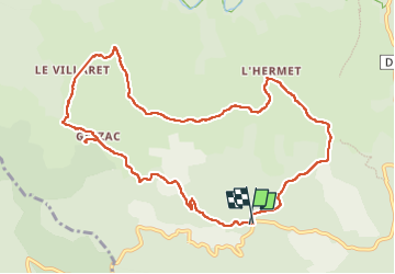

Length
11.4 km

Max alt
1110 m

Uphill gradient
308 m
Km-Effort
15.5 km

Min alt
997 m

Downhill gradient
306 m
Boucle
Yes
Creation date :
2023-02-19 09:36:38.307
Updated on :
2023-02-19 22:49:05.085
3h17
Difficulty : Difficult

FREE GPS app for hiking
 SityTrail
IGN / Geographical institutes
SityTrail Plus
The world is yours!
About
Trail Walking of 11.4 km to be discovered at Occitania, Lozère, Pont de Montvert - Sud Mont Lozère. This trail is proposed by cordierlavenant.
Positioning
Country:
France
Region :
Occitania
Department/Province :
Lozère
Municipality :
Pont de Montvert - Sud Mont Lozère
Location:
Le Pont-de-Montvert
Start:(Dec)
Start:(UTM)
557644 ; 4909106 (31T) N.
Comments